By Tom Herrmann / ADOT Communications
Among the approximately 100 people who joined us Sept. 26 to talk about the Sonoran Corridor – a proposed highway that would connect Interstate 10 and Interstate 19 south of Tucson International Airport – there was some confusion over whether this effort is connected with a similar public involvement effort for the proposed Interstate 11.

The proposed I-11 would be a north-south freeway between Nogales and Hoover Dam, possibly going in or near Tucson and the Phoenix area. The current study is looking for a corridor between Nogales and Wickenburg. North of Wickenburg, it likely would follow the route of US 93.
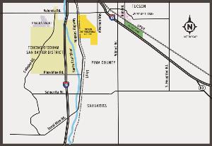
The proposed Sonoran Corridor would run east and west somewhere south of Tucson International Airport. It would be expected to relieve congestion on both I-19 and I-10 in central Tucson, reduce travel times and spur economic development.
These proposed highways have two more things in common:
First, both are years from construction. After ADOT completes Tier 1 Environmental Impact Statements, we would need to do Tier 2 studies to narrow the corridors to specific routes. We would then need to design each route and obtain the needed funding before any work could begin.
Second, we want to hear your thoughts on both proposals. Both project websites provide ways for you to share your thoughts (i11study/Arizona and azdot.gov/SonoranCorridor). We hope you will.
Source: Arizona DMV
